When it comes to drone mapping, accurate georeferencing is crucial for creating reliable orthomosaic maps and digital terrain models (DTMs). Two primary methods dominate: GPS-only positioning and Post-Processed Kinematic (PPK) corrections. While GPS-only mapping is simpler, PPK workflows provide enhanced accuracy that can be vital for precision surveying.
Understanding Accuracy in Drone Mapping
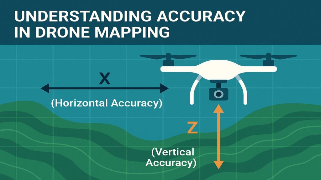
When creating orthomosaic maps, two types of accuracy matter:
1. Relative Accuracy
How well images are stitched together in relation to each other:
- X and Y (Horizontal Accuracy) — How precise the image placement is when viewed from above
- Z (Vertical Accuracy) — Critical for DTMs and elevation analysis
2. Absolute Accuracy
The degree to which the mapped area aligns with real-world coordinates. For GIS, legal boundary work, or integration with existing datasets, absolute accuracy is essential. This is where PPK improves significantly on standard GPS.
RTK vs PPK: Why PPK Might Be the Better Choice
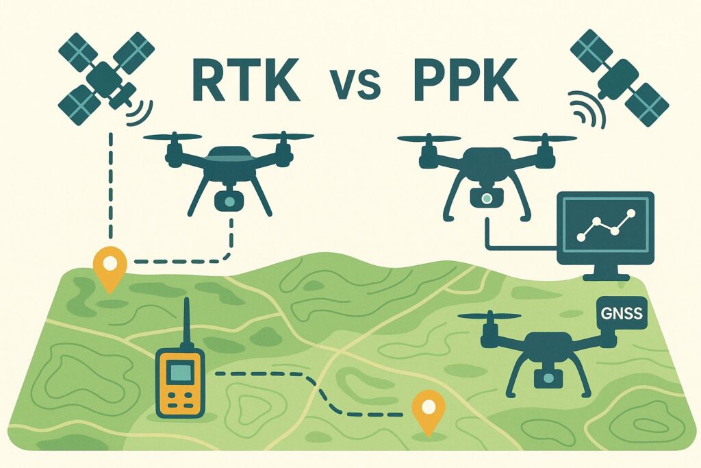
Real-Time Kinematic (RTK) corrections are applied live during a drone flight. While this is ideal in theory, RTK introduces operational challenges:
- Inconsistent or unavailable mobile networks in remote plantation areas
- Distance limitations from CORS stations — must be within 15 km
- Service downtime and subscription expiry issues
- Dependency on stable internet during the flight
PPK resolves these issues by allowing post-processing of GPS data after the flight. The result is comparable accuracy, with far less operational dependency. For a detailed setup guide, see PPK Drone Mapping in India.
Case Study: 20-Acre Plantation Mapping

In a recent project, a 20-acre plantation was mapped using a drone with RTK capability. Due to connectivity issues during the flight, RTK mode could not be activated — the drone collected GPS-only image tags. This prompted us to run PPK correction after the fact using Emlid Studio.
Three datasets were produced and compared:
- GPS Only — Raw images with standard GPS tags
- PPK Float — Corrections applied using data from a CORS station 30 km away
- PPK Fix — Corrections using a virtual base station simulated at the flight coordinates, achieving 100% Fix status
Accuracy Comparison
| Metric | GPS-Only | PPK Float | PPK Fix |
|---|---|---|---|
| X RMS Error (m) | 0.130 | 0.121 | 0.090 |
| Y RMS Error (m) | 0.130 | 0.106 | 0.091 |
| Z RMS Error (m) | 0.340 | 0.333 | 0.167 |
| Total RMS Error (m) | 0.330 | 0.345 | 0.201 |
| CE90 Horizontal Absolute (m) | 0.290 | 0.297 | 0.186 |
| CE90 Horizontal Relative (m) | 0.495 | 0.413 | 0.168 |
| LE90 Vertical Absolute (m) | 0.634 | 0.632 | 0.319 |
| LE90 Vertical Relative (m) | 0.718 | 0.608 | 0.289 |
Interpreting the Results
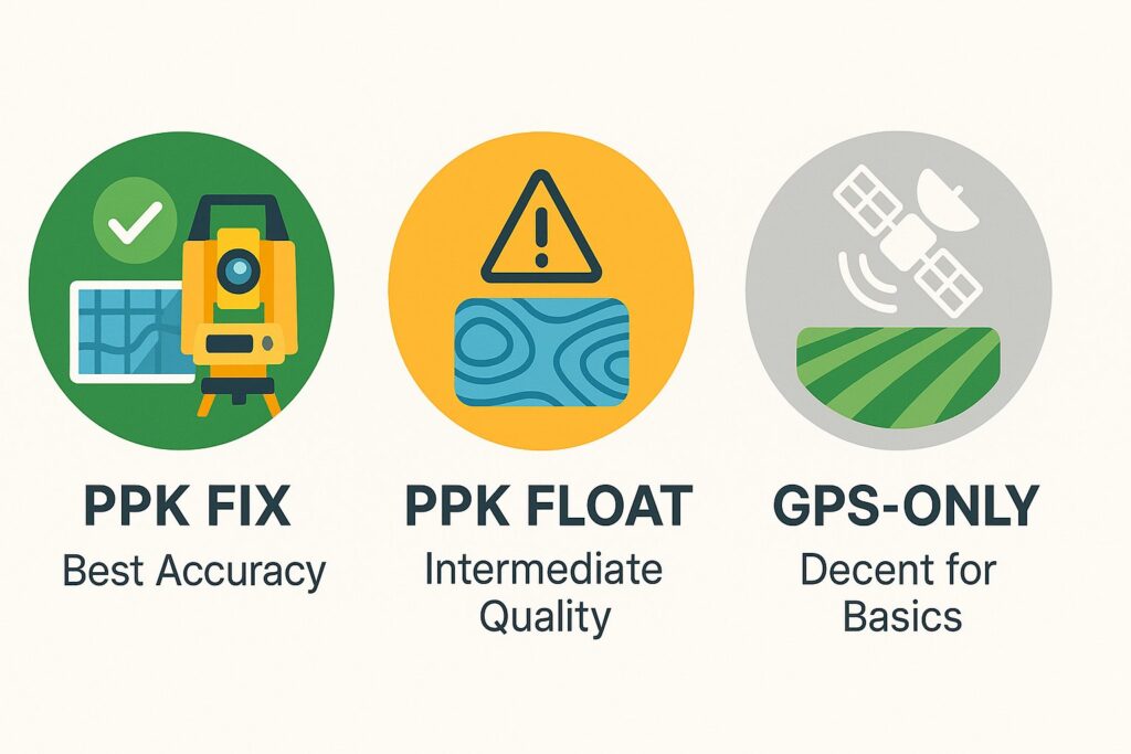
PPK Fix — Best Accuracy
- Delivers sub-decimetre horizontal accuracy and significantly improved vertical precision
- Best choice for surveying, contouring, DTM generation, and engineering-grade work
- Relative CE90 drops from 0.495 m (GPS-only) to 0.168 m — a 66% improvement
PPK Float — Intermediate Quality
- Slightly worse than GPS-only in total RMS error — because partial corrections from a distant base station introduce some inconsistency
- Acceptable for medium-precision applications but not for fine-detail analysis
- The 30 km base station distance in this case study explains the Float result; a closer station or VRS data would have yielded Fix
GPS-Only — Adequate for Basic Use
- Delivers approximately 0.3 m RMS — surprisingly good for standard GPS
- Suitable for basic field mapping where absolute accuracy is not critical
- Not appropriate for legal boundary work, precision drainage planning, or integration with existing GIS datasets
Understanding the Error Metrics
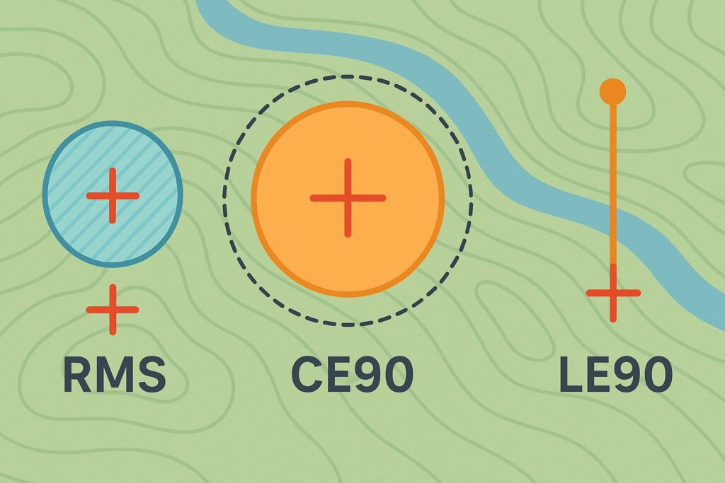
- RMS (Root Mean Square Error) — Measures average deviation from expected GPS positions across all image timestamps
- CE90 (Circular Error 90%) — The horizontal distance within which 90% of horizontal errors fall
- LE90 (Linear Error 90%) — The vertical distance within which 90% of vertical errors fall
Both CE90 and LE90 are reported as Absolute (against real-world coordinates) and Relative (consistency of images against each other).
When to Choose PPK over GPS-Only
| Use case | Recommended method |
|---|---|
| Legal boundary mapping | PPK Fix |
| Slope-corrected area calculations | PPK Fix |
| DTM and drainage planning | PPK Fix |
| NDVI vegetation health mapping | GPS-only is sufficient |
| Quick field overview mapping | GPS-only |
| Integration with existing GIS layers | PPK Fix |
For plantation management purposes at Future Thota, we use PPK Fix for all terrain analysis and area calculation deliverables. For vegetation health (NDVI) analysis, where relative accuracy is more important than absolute georeferencing, GPS-only is typically sufficient.