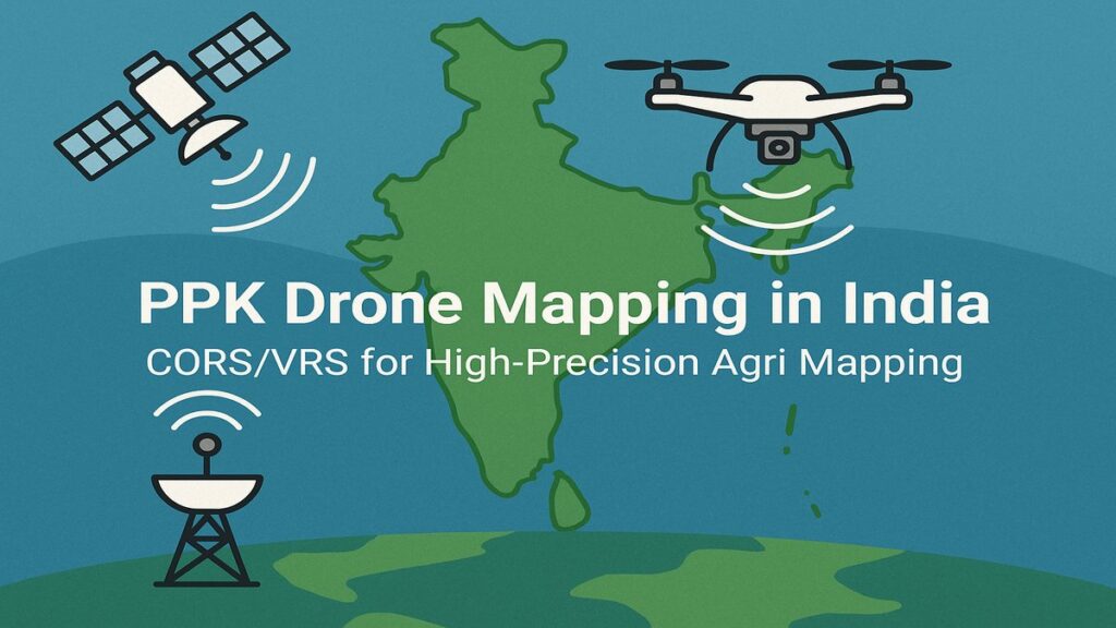
Accurate geo-referencing is critical in drone-based plantation mapping and agri-intelligence. Traditional GPS positioning can have errors up to 30 feet — not suitable for precision agriculture or land assessment. This is where PPK drone mapping offers a cost-effective, high-precision alternative, especially using CORS or VRS data from the Survey of India.
While Real-Time Kinematic (RTK) systems require active network subscriptions and real-time corrections during the flight, Post-Processed Kinematic (PPK) systems allow you to correct GPS coordinates after the flight — achieving centimetre-level accuracy at a fraction of the RTK cost. In many use cases, including agriculture mapping and topographic surveys, PPK is sufficient and more economical.
Why PPK is a Smart Choice in India
PPK does not require a continuous internet connection or an active RTK subscription during flight. Instead, it leverages raw drone GPS logs and precise base station correction data from the Survey of India (SOI), available via:
- CORS Data — From a known SOI CORS base station near your flight area
- VRS Data — Simulated corrections computed at your drone’s exact coordinates
For large-scale or rural operations — such as those Future Thota handles across South India — PPK provides scalable accuracy without real-time infrastructure dependency.
Step-by-Step: PPK Drone Mapping in India
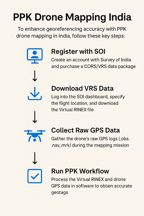
Step 1: Register with Survey of India
- Create an account at the Survey of India website
- Purchase a correction data subscription (options include RDS6, RDS20, or RDS50 depending on your mapping volume)
- These packages allow you to download CORS or VRS RINEX data, which is essential for PPK correction
Step 2: Download VRS or CORS Data
Once logged in to your regional SOI dashboard:
Navigate to Post Processing > RINEX Data. You will have two options:
Option 1: Download CORS Data Select a base station manually — choose one within 15 km of your flight location for best results.
Option 2: Download VRS Data (Recommended)
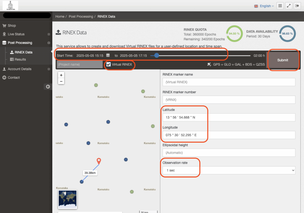
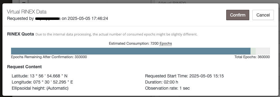
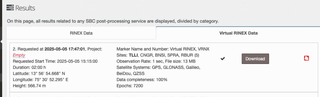
Enter your drone flight’s latitude and longitude, set the time window to span at least 15 minutes before and after the drone flight, and keep the observation rate at 1 second.
The downloaded ZIP includes several files:
.25o— Observations file (used as base).25n— Navigation file (best for base station correction)
Step 3: PPK Workflow Using Emlid Studio
From your drone (typical location in the mission images folder on DJI Enterprise drones):
.obsfile — Raw GPS logs.mrkfile — Image timestamps- Raw images — To be geo-tagged with corrected coordinates
From the VRS or CORS ZIP:
.25o— Base observation file.25n— Base navigation file
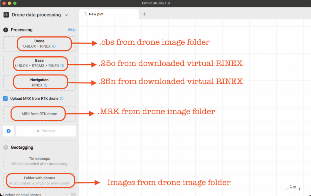
In Emlid Studio:
- Select PPK Processing mode
- Load the drone
.obsand.mrkfiles - Load the base
.25oand.25nfiles - Process to generate a
.posfile (corrected position timestamps) - Apply the corrections to your images before uploading to your photogrammetry software
Step 4: Interpret the Results
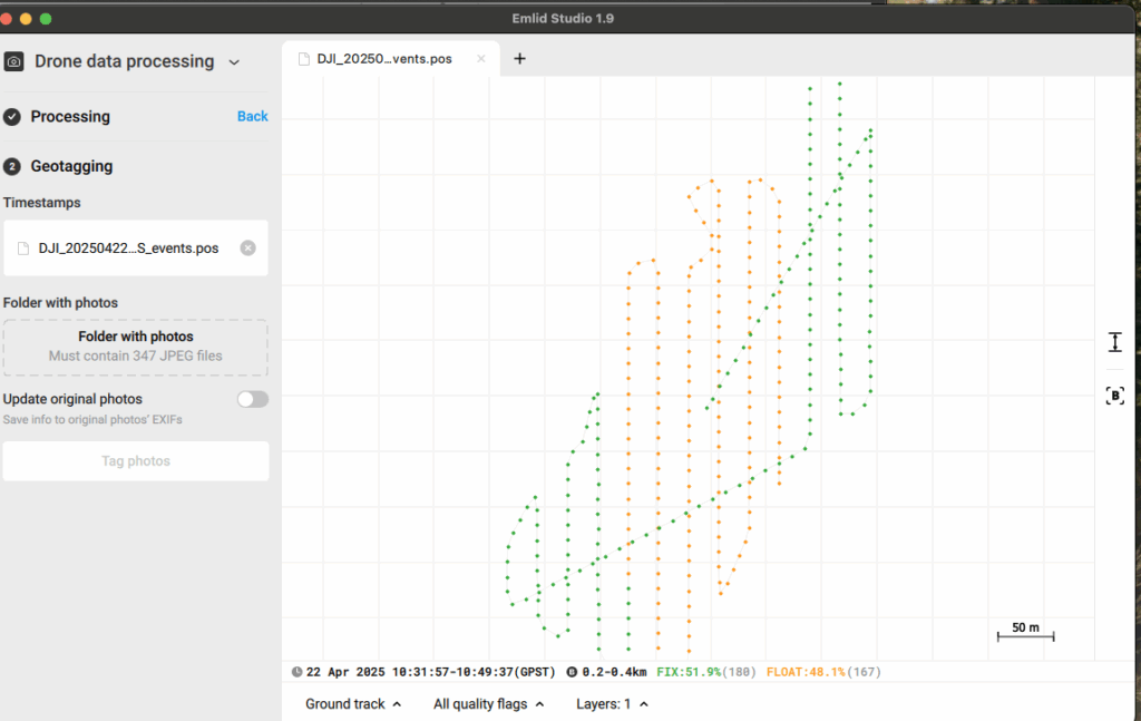
In Emlid Studio, corrected positions are classified as:
- Single — No correction applied (least accurate)
- Float — Partial correction (moderate accuracy)
- Fix — Full correction applied (best accuracy, sub-metre to centimetre level)
A high Fix percentage across image timestamps ensures the quality and reliability of your output orthomosaics and 3D models. Aim for at least 85% Fix before proceeding to processing.
How Future Thota Uses PPK
At Future Thota, we routinely deploy PPK workflows using CORS/VRS data to deliver centimetre-grade mapping for plantations, farm assessments, and irrigation planning. In rural and semi-urban zones where RTK network coverage is sparse, our drone operations rely on efficient post-processing to achieve actionable accuracy.
By integrating VRS correction into our mapping pipeline, we ensure datasets are not only accurate but repeatable — critical for longitudinal crop analysis and investment-grade land documentation.
Summary
PPK drone mapping in India is a practical and scalable solution for professionals needing precise location data without heavy investment in real-time correction systems. With SOI’s growing CORS/VRS infrastructure, it is easier than ever to run high-accuracy mapping projects with minimal overhead.
For a comparison of PPK vs GPS-only accuracy on a real plantation survey, see our PPK vs GPS accuracy case study.
For agriculture, land development, or environmental monitoring, this workflow balances affordability and precision — exactly the kind of edge Future Thota delivers to its clients.